
ABOVE: Huntington Beach near pier and bandshell, circa 1914. (Photo, Library of Congress)
The Huntington Beach pier--#2 on the Historic Downtown walking guide--has been a fixture on our coast for well over one hundred years. (See a photograph of the original 1902 rough pine industrial pier at http://www.historichuntingtonbeach.blogspot.com/2012/05/surf-city-ninety-eight-years-ago-this.html).
Listed on the National Register of Historic Places in 1989, the older pier was considered "locally important because it was constructed for the express purpose of establishing the city of Huntington Beach as a West Coast resort community" and because "it embodies elements of architectural design and engineering that were advanced for its period of construction, and is a rare surviving example of early 20th century reinforced concrete marine structures in the United States."
Like a phoenix, the pier has risen a half dozen times after storms and ocean wear-and-tear have taken it out. It would not be Huntington Beach without the pier. Take a walk through time before you walk down the pier.
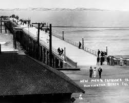
 ABOVE: The "new" pier with a view of Catalina Island, circa 1914.

ABOVE: Datestone for the Huntington Beach pier, 1914. (Photo, Library of Congress)

ABOVE: Pier and bandshell, circa 1914. (Photo, Library of Congress)
 ABOVE: Looking from Main Street and Ocean Boulevard (present-day Pacific Coast Highway) to pier, circa 1914. The "Pride of the Pacific"--designed by Ernest Rothenberg--is 1316 feet. (Photo, Library of Congress)


ABOVE: A saltwater "plunge" was a popular feature next to the pier, circa 1922. (Photo, Library of Congress)

ABOVE: The 1850-foot pier, circa 1930. The pier suffered damage during the 1933 Long Beach earthquake. (Photo, Library of Congress)

ABOVE: Longest pier on the coast, with "sun rooms," circa 1935. In 1939, a hurricane tore off the end of the pier and it was rebuilt in 1940 to a length of 1822 feet. (Photo, Pomona Public Library)
 ABOVE: South side of pier, circa 1940s. Note ship off end of pier.


ABOVE: Pier post WWII, re-opened to the public, circa mid 1945. During the war, the U.S. Army used the pier for submarine watch and equipped it with a gunnery. (Photo, Library of Congress)

ABOVE: Pier photographed by California Department of Fish and Game, circa 1949. Note oil well derricks throughout Huntington Beach.

ABOVE: Huntington Beach pier, circa 1950s. (Photo, Los Angeles Public Library)

ABOVE: Tandem competition next to pier, circa 1962.
 ABOVE: El Nino storm strikes the pier and the cafe is lost to the sea, circa 1983. After another damaging storm in 1988, the pier was rebuilt following the 1914 design. (Photo, Orange County Register)


ABOVE: Aerial view of pier looking toward Main Street, circa mid 1980s, before re-construction. (Photo, Library of Congress)
 ABOVE: View from end of pier deck toward Main Street and Pacific Coast Highway, circa mid 1980s. (Photo, Library of Congress)
 ABOVE: Captains Gallery, circa mid 1980s. (Photo, Library of Congress)
 ABOVE: Maxwell's Restaurant at the foot of the pier, circa mid 1980s (at the site of present-day Duke's). (Photo, Library of Congress)
 ABOVE: Neptune's Locker, circa mid 1980s. (Photo, Library of Congress)
 ABOVE: Underneath the pier, circa mid 1980s. (Photo, Library of Congress)
 ABOVE: U.S. Open, 1999. The pier reopened in 1992 and is 1853 feet long. (Photo, surf.transworld.net)
 ABOVE: Water spout at end of pier, El Nino of February 2005 (we survived this one). (Photo, NOAA / NWS)

 ABOVE: The pier is the heart and soul of Huntington Beach. Surfers' "paddle out" for the late Sean Collins of surfline.com, January 2012. (Photo, Sacramento Bee)
© All rights reserved. No part of the Historic Huntington Beach blog may be reproduced or duplicated without prior written permission from the author and publisher, M. Adams Urashima.


ABOVE: Cattle drive on beach, circa 2007, in conjunction with the U.S. Open of Surfing.
 ABOVE: Surfing the Huntington Beach pier is almost a century-old tradition. Visitors and locals alike walk down the pier, lean against the railing, and watch the experts at work. (Photo, Sacramento Bee)


© All rights reserved. No part of the Historic Huntington Beach blog may be reproduced or duplicated without prior written permission from the author and publisher, M. Adams Urashima.
When we arrived in CA in Feb 1960, Coast Highway was in the middle of construction. We arrived in the middle of a storm, so could not see much when we arrived. We stayed that night at the "Sun-N'Sands" motel on Coast highway, and with care, my sister and I could hop across and through the road construction to the beach.
ReplyDeleteRemnants of both the old Coast Highway and the Oil Co. service roads appear to be there yet (curbs and pieces of pavement ).
The OLD coast Highway was really narrow - two lanes, one in each direction. The oil wells were still right on the beach cliffs, at the edge. The beach between the Cliffs and Sunset Beach still had the railroad running along it, all the way to the pier. A few years later, I got to see the last train ever to run along the beach. I was surfing at the West (North; the Long Beach end) end of the cliffs at the time. It was still "Tin Can Beach" then, and you had better wear shoes, and have your tetanus shots up to date, on account of the thick litter of rusty (STEEL!) beer cans!
There was a railroad caretaker house across Warner at Coast Highway (Across from where Jack-in-the-box is now) where a kid named "Vincent" lived with his family. His father worked for the railroad. It was a comparatively lonely stretch of road then. There were still MANY (maybe THOUSANDS!) of oil wells in service throughout Huntington Beach.
The Coastal Battery gun emplacement revetments (the guns gone, of course!) and the Gun Club were where the salt marsh preserve is now.
...another world, for sure and for certain. You could still drive between the Golden Bear (right near Groth Chevrolet) Remember that?) and Los Alamitos in less than 20 minutes (no 22 or 405 freeways!)... can't do that anymore!
I remember the open spaces and minimal population at the beach; surfed
Deletethe Huntington cliffs in the am and Trestles at glass off and surfed until sunset. That was 1962 on a Velzy Jacobs pin tail 1 stringer.
I did as well! My dad surfed there in the 1940's and I grew up there in the 50's/60's+. Sad to go down there now. You actually used to be able to see the water from PCH. It was 10min from Disneyland to the beach down Brookhurst. Grunnun hunts in the summer, best time ever growing up there.
DeleteOh! Forgot one of my favorite things was to go with my friends to the building at the pier by the concrete bleachers and get the little printed metal tags with our boyfriends names!
DeleteTim Buckley went to school with us and played at the Golden Bear. Very cool place to be in the 60's! Of course Huntington was always such a fun place to be. The boys would cut school on good surf days and girls surfing were rare. I was one of the rare ones and the waves always cleared when I was in the water. Bikini's were in and skate boards were all home made. We put carpet on the fancy ones so we could skate barefoot.
DeleteThank you very much for adding to the history and memories of Huntington Beach!
ReplyDeleteI remember eating bean and cheese nachos at The End Café circa 1976. OMG! so delicious! I also remember the 1983 &1985 storms that took our pier down.
ReplyDelete